 News
News
Storm Hanna Becomes Hurricane As It Heads To Texas Coast, Two Other Storms Threaten Hawaii And The Caribbean

 July 25, 2020
Storm Hanna on Saturday morning strengthened and became Category 1 hurricane of the 2020 Atlantic season, as it is set to make landfall along the Texas coast in the afternoon or early evening, the U.S. National Hurricane Center said.
Hanna, the first hurricane of the season in the Atlantic, had sustained winds of 75 mph around 7 a.m. CT (8 a.m. ET), and its center was about 100 miles east-southeast of Corpus Christi.
It is forecast to make landfall along the Texas coast, likely somewhere between Corpus Christi and Brownsville, in the afternoon or early evening, the National Hurricane Center said.

Some additional strengthening is possible before Hanna strikes land.
A hurricane warning is in effect for Port Mansfield to Mesquite Bay. And a storm surge warning — meaning life-threatening surges of water from the coastline is possible — is in effect from Port Mansfield to Sargent.
Storm surges of up to 5 feet are possible in some areas, including Corpus Christi Bay.
Heavy rain — 6 to 12 inches — is expected in south Texas and the Mexican states of Coahuila, Nuevo Leon and Tamaulipas through Sunday night.
About 3 to 5 inches of rain are expected along the upper Texas and Louisiana coasts.
A hurricane in the Atlantic at this time of year is somewhat ahead of the norm. The Atlantic’s first hurricane does not normally form until about two weeks into August.
Hanna is on track to become the first hurricane to hit Texas in the month of July since Hurricane Dolly in 2008.
Hurricane Douglas
Hurricane Douglas is approaching Hawaii but is forecast to weaken before it reaches the island chain this weekend.
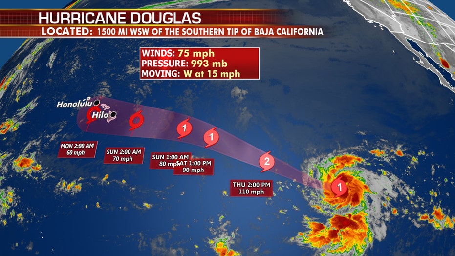
Douglas peaked as a Category 4 storm early Friday and is now a Category 2 storm with winds of 110 mph. Steady weakening is expected to continue over the next 36 hours as it approaches Hawaii.
“Recent model trends indicate a northward shift to the path of the hurricane. Regardless of its exact track and whether it makes a direct landfall, severe impacts are still anticipated across the islands as the threats extend well away from the center of the storm,” US NHC said. “Hurricane-force winds extend 25 miles from the center and tropical-storm-force winds extend outward up to 105 miles, meaning this doesn’t need to be a direct landfall to have serious consequences.”
When Douglas reaches the island chain Saturday evening or Sunday morning, it will likely be a Category 1 hurricane or strong tropical storm, forecasters said.
A hurricane watch is in effect for all of Hawaii except the island of Kaua’i.
Hawaiian Airlines canceled all neighbor island flights on Sunday, in addition to select flights Sunday evening between Honolulu and Maui and the island of Hawaii, according to a statement.
Douglas will bring the threat of flash flooding and landslides/mudslides, along with strong winds that may cause power outages and damaging surf.
Tropical storm-force winds are forecast to arrive on the island of Hawaii as early as Saturday evening local time. The hurricane center forecast between 6 to 10 inches of rain for portions of the islands with isolated maximum totals of 15 inches are possible, especially in higher terrain.
The storm also will create large swells that are likely to cause life-threatening surf and rip current conditions for several days.
Tropical Storm Gonzalo
Tropical Storm Gonzalo is set to move through the southern Windward Islands on Saturday, bringing heavy rain and strong winds to the islands.

Gonzalo is no longer expected to impact the larger islands of the West Indies — including Trinidad, Tobago, Barbados, Martinique and St. Lucia — as a strong tropical storm or Category 1 hurricane, but now as a weaker tropical storm.
Rainfall is expected to total 1 to 3 inches for much of the affected areas.
Gonzalo is expected to weaken and dissipate at the beginning of next week as it moves through the southern Caribbean.
Gonzalo has already set the record for the earliest-named seventh storm, in what is shaping up to be a busy hurricane season.
The center is forecasting the storm to weaken slightly before moving over the Windward Islands. The storm may even fizzle after it moves over the islands, as many models are indicating, or it could continue to intensify into next week. It’s still a little too early to tell exactly what it will do after it moves into the Caribbean.
Also Read : News Highlights From July 2020
Recent Posts
- Pakistan Opens Doors to Boost Tourism and Business with Free Visas for 126 Countries
- Disney’s “Inside Out 2” Becomes the Highest-Grossing Animated Film Ever
- South Korea Cracks Down on Crypto Exchange Fees
- Ava Kris Tyson Departs MrBeast Following Grooming Allegations
- Apple’s iPhone SE 4: What do we know so far?
- ‘Inside Out 2’ Crushes Box Office and Enters the Billion-Dollar Club
- Telegram Founder Backs Viral Crypto Game Hamster Kombat, Calls it a New Era for Blockchain
- End of the Road for Self-Lacing Nikes: App Shutdown Leaves Adapt BB Owners with Limited Functionality
- Chaotic Encounter During European Tour Leaves IShowSpeed Injured and Frightened
- Quirky RPG ‘Thirsty Suitors’ Coming Soon to Mobile on Netflix Games